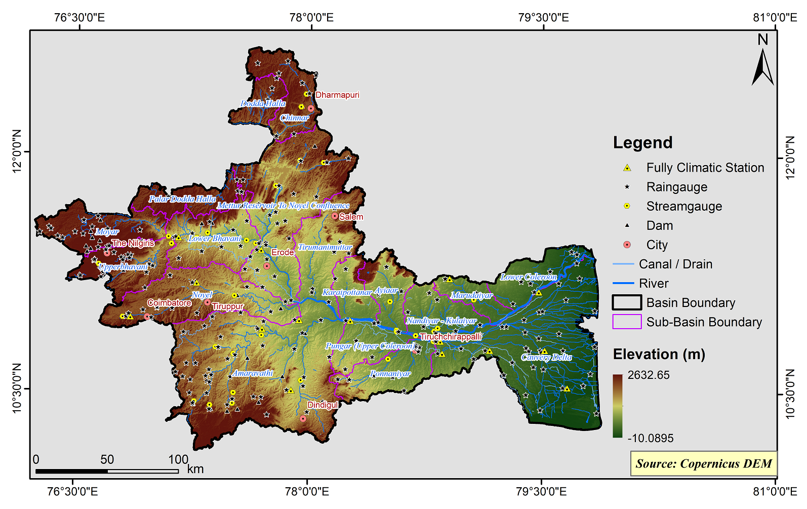
Cauvery Basin
The Cauvery basin extends over states of Tamil Nadu, Karnataka, Kerala and Union Territory of Puducherry, draining an area of 85,626.23 Sq.km, which is nearly 2.7% of the total geographical area of the country with a maximum length and width of about 560 km and 245 km, respectively. Out of this, 42% area lies in Karnataka, 54% area in Tamil Nadu & Karaikkal region of Puducherry and 4% in Kerala. It is bounded by the Western Ghats on the west, by the Eastern Ghats on the east and south and by the ridges separating it from Krishna basin and Pennar basin on the north. The three main physiographic division of the basin are the Western Ghats, the plateau of Mysore and the Delta. The Cauvery River is one of the major rivers of the peninsular India. It rises at an elevation of 1,341 m at Talakaveri on the Brahmagiri range near Cherangala village of Kodagu district of Karnataka and drains into the Bay of Bengal. The total length of the river from origin to outfall is around 800 km. Its important tributaries joining from left are the Harangi, the Hemavati, the Shimsha and the Arkavati whereas the Lakshmantirtha, the Kabbani, the Suvarnavati, the Bhavani, the Noyil and the Amaravati join from right. The utilizable surface water resource for the basin is 19 BCM. The Average Annual Runoff and Average Annual Water Potential in the basin are same as 21.36 BCM. The major part of basin is covered with agricultural land accounting to 66.21% of the total area and 20.50 % of the basin is covered by forest area.
The Cauvery Basin consists of 18 Sub-Basins and their areal extent are as follows
|
Name of the Sub-basins |
Total area of the Sub-basin (km2) |
|
Ayiaar |
1326.51 |
|
Amaravathi |
9253.53 |
|
Upper Bhavani |
1806.91 |
|
Chinnar |
1749.77 |
|
Cauvery Delta |
7303.15 |
|
Dodda Halla |
835.89 |
|
Karaipottanar |
1001.37 |
|
Ponnaniyar |
1798.69 |
|
Lower Bhavani |
2402.59 |
|
Lower Coleroon |
1500.56 |
|
Marudaiyar |
877.16 |
|
Mettur Reservoir To Noyel Confluence |
5404.84 |
|
Moyar |
2066.57 |
|
Nandiyar - Kulaiyar |
1532.27 |
|
Noyel |
3535.82 |
|
Palar Dodda Halla |
1292.95 |
|
Pungar (Upper Coleroon) |
1308.70 |
|
Tirumanimuttar |
2476.97 |
 |
|---|
|
|
Projected Water Balance
Base Period (1985-2014) Future Period (2021-2050)
Climate Risk
Base Period (1985-2014) Future Period (2021-2050)

